

To cross this river is an essential and integral part of community life, both past and present. At one time it meant traversing the 'prehistoric ford', located directly below the suspension bridge. In 1903 a temporary suspension bridge was shifted from Kuripapango to a location near the site of the current suspension bridge, however for foot traffic only. The demand for a traffic bridge was high, as recorded in the Taihape Daily Times on the 9th of October, 1916, which expressed 'That bridge is now needed so urgently to complete road communication with the block of land given for Maori Settlement and the great Mangaohane block of land given for Maori'.
Maori movement in this area has a long history. The bridge crosses the Rangitikei River at the same spot as did generations of Maori trekking the 'Inland Patea' route. This route is an old Maori trail from the East Coast to the centre of the North Island. After another significant flood in 1958, one of the very few Moa hunting sites in the North Island was revealed not far upriver.
European history dates from the mid-nineteenth century when Reverend Richard Taylor and the missionary William Colenso both travelled the historic route, spreading their Christian beliefs. The first European sheep farm was established by Captain Azim Birch and his brother William when they bought the land between the Moawhango and Rangitikei Rivers in 1867. They named the area Erehwon, spelling 'nowhere' backwards. Later renamed Erewhon riding, this area went on to become a well-known example of the late nineteenth century post World War One settler programmes, in which large tracts of marginal land were opened up for development.
The erection of a traffic bridge was therefore vital to expanding agriculture in the Rangitikei district at this time. It was needed to facilitate easier access to the farms inland and for the movement of stock and wool to the port of Napier. It also would be valuable to the social life of the communities, providing a link to the rest of the country and thus opportunities to enjoy travel as a leisure pursuit. For the people in this area the bridge represented a chance to strengthen ties amongst communities and increase social networks.
The Springvale Suspension Bridge was designed by S.A.R. Mair (Sydney), the Engineer of the Rangitikei County Council from 1899 to 1947. Tenders were called for and by November 1923 one was accepted from William Salt, a bridge contractor from Wanganui. Salt went on to become a successful bridge designer; despite his short career he built many major river crossings in the Rangitikei, Wanganui and Waitotara regions. The Springvale Suspension Bridge was his major achievement, and may be the only bridge he built that is extant.
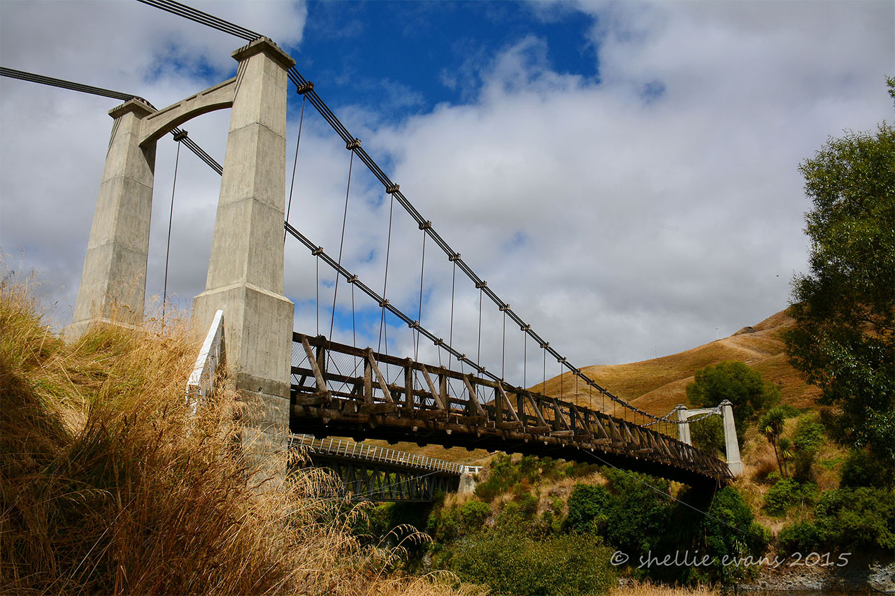
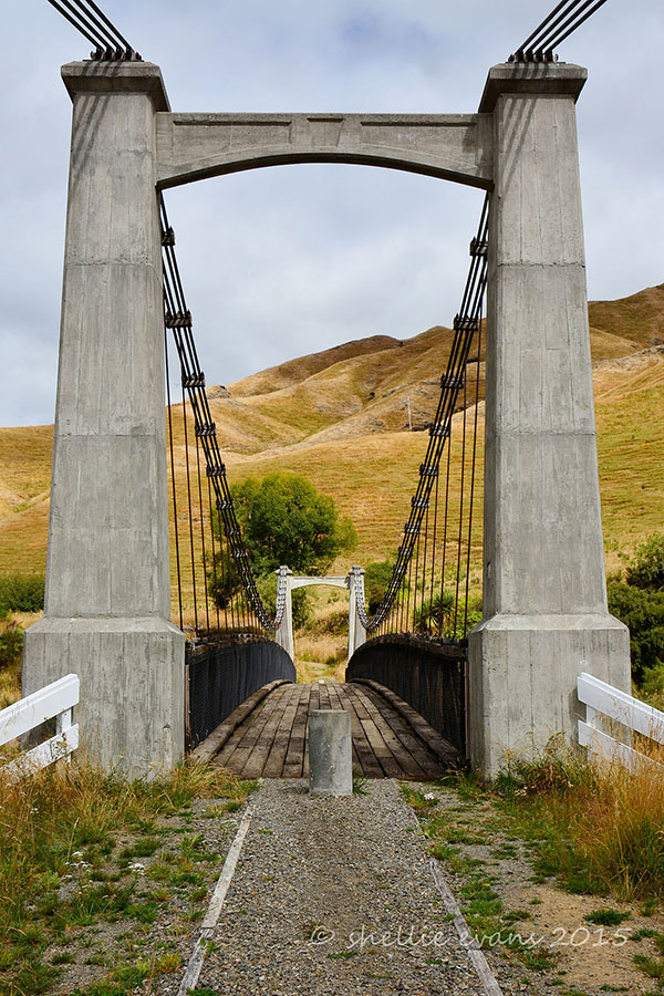
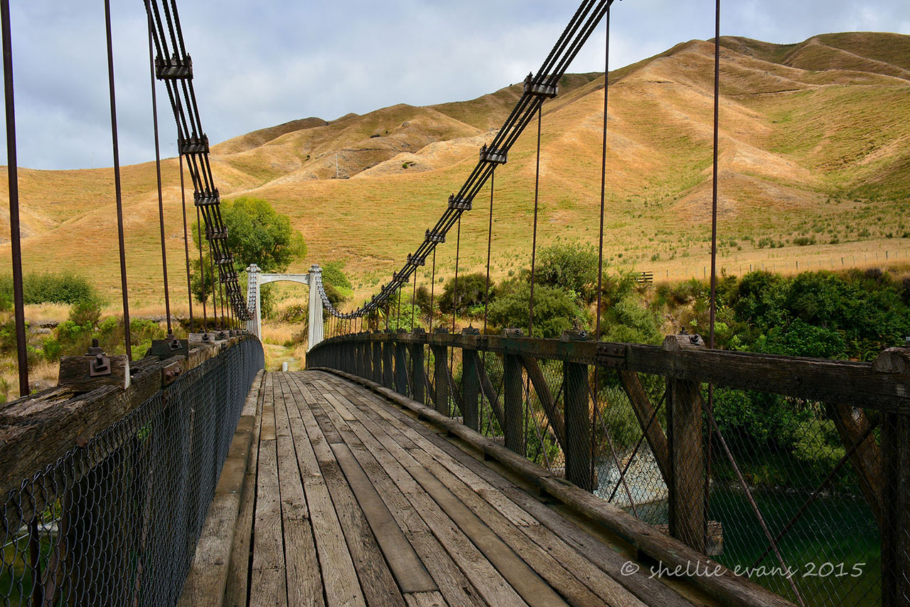
Construction was completed in early 1925, and cost £4473 13s 6d. The Erewhon Bridge, as it was then unofficially known, was opened in early April in time for the Easter holidays. A 61 metre long structure of reinforced concrete, steel and Australian Hardwood decking, it is visually inspiring and an impressive engineering achievement. The seven metre tapered concrete towers are anchored by large concrete blocks below ground level. The bridge utilises 140mm cables made of plough steel wire with a breaking load of 12 tonnes. Diagonal sway bracing can be seen from beneath the bridge, with sway cable anchoring the bridge to the banks.
Due to an increasing amount of vehicles using the bridge over a 45 year period, repairs were becoming more frequent and it became apparent that a new bridge would have to be built to accommodate the rising traffic numbers. Thus in 1970 the Callender-Hamilton Bridge was constructed less than 50 meters away. Threatened with demolition, R.A.L. Batley (Tony) of Moawhango advocated for the preservation of the bridge through his recommendation in 1974 that it be bought by the New Zealand Historic Places Trust.
The Springvale Suspension Bridge is registered as a Category II Historic Place in recognition of its historical and social value and its significant technological design. Once a common sight in New Zealand, today there are only a few of these bridges that remain in working order and have a viable future. Its presence is testament to the bridge's durability and lasting significance. It is an iconic achievement of engineering of the era, exhibiting the pioneering spirit of overcoming the challenges of the terrain and achieving the expansion of settlement into the 'Inland Patea' and indeed the interior of the country.
List Entry Information
Status
Listed
List Entry Status
Historic Place Category 2
Access
Able to Visit
List Number
7535
Date Entered
2nd April 2004
Date of Effect
2nd April 2004
City/District Council
Rangitīkei District
Region
Horizons (Manawatū-Whanganui) Region
Extent of List Entry
Extent includes part of the land described as Pt Mangaohane 1A (RT 579185), part of the land described as Legal Road and part of the land described as Legal River, Wellington Land District and the structure known as Springvale Suspension Bridge thereon, and its fittings and fixtures. (Refer to the extent map tabled at the Heritage List/Rārangi Kōrero Committee meeting on 8 October 2015.)
Legal description
Pt Mangaohane 1A (RT 579185), Legal Road, Legal River, Wellington Land District
Location Description
This highway is also known as the Gentle Annie, which is a remote route 150 kilometres long through the Kaweka Ranges; 30 kilometres of it is unsealed. The suspension bridge is located on this road 40 kilometres from Taihape.
Construction Professional
Name
Mair, S.A
Type
Engineer
Biography
No biography is currently available for this construction professional
Name
Salt, W
Type
Builder
Biography
A bridge contractor from Wanganui.
Construction Details
Start Year
1903
Type
Other
Description
Old Kuripapango suspension bridge is shifted to the site for foot traffic
Start Year
1922
Type
Designed
Description
Plans of Bridge drawn up by S.A.R. Mair
Start Year
1923
Type
Original Construction
Description
Construction commenced by William Salt, contractor
Finish Year
1925
Type
Original Construction
Description
Construction completed and bridge opened in April
Start Year
1970
Type
Other
Description
Replacement bridge opened in August
Start Year
1885
Type
Other
Description
Road from Kuripapango reaches the Rangitikei River
Construction Materials
Concrete, Steel, Australian Hardwood
The bridge rests on two pieces of privately owned land. It has no separate legal description of its own. The legal description below is the current legal description of the two pieces of privately owned land on which the bridge sits: - Eastern Abutment: CT8D/1474,Pt 1A, Mangaohane Blk, ML 1160 SO 28440 - Western Abutment: CT142-164,Pt 1o Oruamatua- Kaimanawa Blk, ML 1421, SO28440 - Block XI Motupuha Survey District.
The bridge rests on two pieces of privately owned land. It has no separate legal description of its own. The legal description below is the current legal description of the two pieces of privately owned land on which the bridge sits: - Eastern Abutment: CT8D/1474,Pt 1A, Mangaohane Blk, ML 1160 SO 28440 - Western Abutment: CT142-164,Pt 1o Oruamatua- Kaimanawa Blk, ML 1421, SO28440 - Block XI Motupuha Survey District.
Historical and Associated Iwi / Hapū / Whānau
Completion Date
11th January 2010
Report Written By
Louise Hawthorne
Information Sources
Batley, 1970
Heritage Trails: Inland Patea, Taihape - Hastings, Rangitikei, published by the Rangitikei Heritage Trail Working Party.
New Zealand Historic Places Trust (NZHPT)
New Zealand Historic Places Trust
Taihape Daily Times
Taihape Daily Times
Other Information
Please note that entry on the New Zealand Heritage List/Rarangi Korero identifies only the heritage values of the property concerned, and should not be construed as advice on the state of the property, or as a comment of its soundness or safety, including in regard to earthquake risk, safety in the event of fire, or insanitary conditions.
Current Usages
Uses: Transport
Specific Usage: Bridge/ Viaduct
Former Usages
General Usage: Transport
Specific Usage: Bridge/ Viaduct
Web Links
description: Engineering NZ Heritage
url: https://www.engineeringnz.org/our-work/heritage/heritage-records/springvale-suspension-bridge/
Current Usages
Uses: Transport
Specific Usage: Bridge/ Viaduct
Former Usages
General Usage: Transport
Specific Usage: Bridge/ Viaduct
Web Links
description: Engineering NZ Heritage
url: https://www.engineeringnz.org/our-work/heritage/heritage-records/springvale-suspension-bridge/
Location
Sign up to hear more
Get the latest heritage news, features and events delivered
straight to your inbox.
